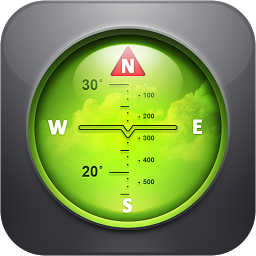
 Spyglass v3.9.9
Spyglass is an essential offline GPS app for outdoors and off-road navigation. Packed with tools it serves as binoculars, heads-up display, hi-tech compass with offline maps, gyrocompass, GPS receiver, waypoint tracker, speedometer, altimeter, Sun, Moon and Polaris star finder, gyro horizon, rangefinder, sextant, inclinometer, angular calculator and camera. It saves a custom location, navigates precisely to it later, shows it on maps and using augmented reality displays detailed GPS info, measures distances, sizes, angles, and does a lot more.
Features of Spyglass
Compass & gyrocompass
- Accuracy improvement techniques, special compass modes and calibration methods available in Spyglass only make it a real instrument – the most advanced and accurate digital compass.
Finder, tracker & AR navigation
- Spyglass operates in 3D and uses augmented reality to show object positions, info and directions to them overlaid over camera or maps.
- Save current position, add a point from maps, manually enter location coordinates.
- Find the saved place later simply by following directional arrows.
- Spyglass tracks your target and shows its info – distance, direction, azimuth, elevation and estimated time of arrival.
GPS, speedometer & altimeter
- Find and track your location and get detailed GPS data – coordinates in dozens of formats, altitude, course, current, maximum and vertical speed, using imperial, metric, nautical and surveying units.
Offline maps
- See your and targets’ positions on maps using different map styles and alternative map providers – plan waypoints and measure distances. Offline maps optimized for retina displays are available for download.
Track polaris, sun and moon & navigate by stars
- Track positions of Polaris, Sun and Moon with arc second precision – use them as a reference to calibrate compass for maximum accuracy.
Optical rangefinder
- Measure distances to objects in real time with a rangefinder reticle similar to sniper sights.
Sextant, angular calculator and inclinometer
- Find out heights of objects and distances to them – measure visually and calculate dimensions and distances.
Camera
- Take pictures overlaid with all available GPS, positional and directional data.
- Stoxy PRO - Stock Market Live 7.0.2
 Easily follow your stocks, indices, futures from the US, EU, and Asian markets
 - Resume Builder: CV maker PDF 6.3.1
 A mobile application that allows you to create a professional resume or CV (curriculum vitae) on your smartphone
 - Noteshelf - Notes, Annotations 8.5.0
 An app available on iOS and Android devices that gives users a variety of tools for note-taking and annotation
 - Notes 12.0.18
 The easiest way to keep track of your thoughts and ideas
 - LectureNotes 2.10.3
 An Android app for note-taking by handwriting on the screen, in particular with a stylus
 - Expenso - Money Manager 1.1.80
 Budget management and spending tracker android app will help you manage your personal finances easily
 - Currency Converter Plus 3.1.10
 The currency converter uses the most up-to-date exchange rates to ensure the most accurate conversions possible
 - Calculator - Floating Apps v2.3.6
 Supports percent calculation, constant calculation, repeat and exponential, and interest calculation
 - Business Calendar 2 Pro 2.53.8 build 253801
 Gives you powerful tools to plan and schedule your events and tasks
 - Bookmark Folder 5.2.14
 This app can organize your bookmarks in bulk, and you can choose to launch the browser for each bookmark