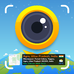
 GPS Map Camera 2.1.2
GPS Map Camera will help users save memorable moments with extremely detailed information about where and when they took that photo. Now just by looking at the photo, you can immediately remember when, where and how you took this photo. GPS Map Camera will provide you with an extremely sharp photo capture tool with a very good image processing system, so your photos will be of very high quality. Besides, the photo function of this application can also intelligently identify objects to focus the frame on that object and create beautiful images. Not only that, but when you finish taking photos, this application also allows you to add information related to the geographic location of the shooting location.
With the GPS map camera, users can freely change, add or delete information displayed on the image. Thanks to this feature, you can easily customize the amount of information you want to appear on the image in just a few simple steps. Besides, it has a map viewing function with different representations such as topographic maps, wind maps and satellite maps. The extremely interesting functions of this application will become a useful tool to help record your memorable moments easier and more convenient than ever.
Features of GPS map camera
- Geotaging: The application uses your device's GPS to automatically tag your photos with the exact location where they were taken. This information is embedded in the photo's metadata, allowing you to view the location on a map or share it with others.
- Timestamp: GPS map cameras also add timestamps to your photos, indicating the date and time when the photo was taken. This can be useful for organizing and referencing your photos chronologically.
- Customizable text overlays: Apps often allow you to add customizable text overlays to your photos. You can include information such as address, elevation, distance, speed, and other details on the image itself.
- View a map: GPS map cameras often offer a built-in map view that lets you see the exact location where the photo was taken. You can view the map directly in the app and navigate to the location if needed.
- Export and Share: Once you have captured a geotagged photo with the GPS map camera, you can save it to your device's gallery or share it with others via social media platforms, email, or messaging apps. Embedded GPS information can be retained when sharing the photo, allowing recipients to view the location data.
- Tayasui Sketches 1.5.41
 The most practical tools, enhanced with a large number of advanced functions and a minimalist and intuitive interface
 - Sun Locator Pro 4.5 build 102
 A mobile app that helps users determine the location of the sun
 - PhotoDirector: AI Photo Editor 20.9.2
 Photo editing app for Android devices allows you to edit and enhance your photos with many tools, effects
 - Photo Lab PRO Picture Editor 3.13.77
 Allows users to enhance and transform their photos with a variety of filters, effects, and frames
 - LINE Camera - Photo editor 17.4.0
 Take quick photos with your internal camera, use Live filter and Beauty features to show the world the real you
 - Lightroom Photo & Video Editor 11.1.1
 A powerful, free camera and photo editor app that powers your photography, helping you take and edit stunning photos
 - Gallery Elite 1.26
 The premium gallery app for Android devices offers advanced features to manage and organize photos and videos
 - Camera Auto Timestamp 3.13
 This app will automatically print timestamp on your photos as you take them with your built-in camera
 - AI Enhancer, AI Photo Enhancer 1.0.9.25
 Provide features such as automatic color correction, noise reduction, and object removal use artificial intelligence AI
 - 3D Modeling App: Sculpt & Draw 1.20.7
 A 3D modeling application that allows users to create and sculpt 3D models using a variety of tools and features