 Skyline TerraBuilder Enterprise 7.2.0 Build 1472
TerraBuilder is a 3D terrain database builder with professional tools for manipulating and stitching aerial photos, satellite images, and digital elevation models of various sizes and resolutions. The resulting high-fidelity, geographically accurate terrain database can be delivered to local TerraExplorer clients or published to remote clients (using the SkylineGlobe Terrain service).
Key features and capabilities include: Data Integration and Editing: TerraBuilder supports multiple....
Thanks for Downloading
TerraBuilder is a 3D terrain database builder with professional tools for manipulating and stitching aerial photos, satellite images, and digital elevation models of various sizes and resolutions. The resulting high-fidelity, geographically accurate terrain database can be delivered to local TerraExplorer clients or published to remote clients (using the SkylineGlobe Terrain service).
Key features and capabilities include:
- Data Integration and Editing: TerraBuilder supports multiple file formats and coordinate systems, automatically reprojecting layers as needed. It provides editing tools to crop, resize, move, blur, adjust geographic coordinates using tie points, and modify color and elevation parameters to ensure accurate terrain database creation.
- Scalability and Performance: The Enterprise edition allows the workload of creating large 3D terrain databases to be distributed across multiple computers and processors on a network. This parallel processing significantly reduces the time required to create and optimize the terrain database.
- Export and Publish: Completed projects can be processed into a single threaded optimized (MPT) file for local use in Skyline TerraExplorer or published directly to SkylineGlobe Server. The server can stream terrain data on demand via the DirectConnect Service, eliminating the need for time-consuming pre-processing and providing dynamic updates.
- Interoperability: TerraBuilder supports the use of output data by local TerraExplorer clients, remote users via SkylineGlobe Server, and OGC-compliant standard clients using the WMS/WMTS protocol.
- High-resolution visualization: TerraBuilder uses a resolution pyramid to display multi-level performance, displaying lower-resolution versions when zoomed out and higher-resolution layers when zoomed in, maintaining fast and efficient visualization.
Top Alternatives
- UML Diagrammer 6.76
 Create and maintain UML diagrams with templates are included for the type of diagram UML 2.0 downloads
 - Starre Enterprises BoxMinder Pro 8.30
 Software application designed to help businesses or individuals manage the sending and notification of packages via Email
 - NemaStudio 1.36.6465.25714
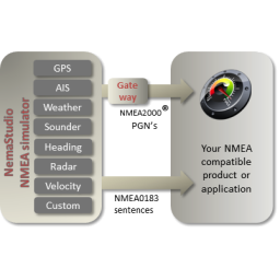 Versatile tool for simulating AIS and Radar targets and many other marine devices
 - NCSS: Statistical Software 2026 v26.0.1
 Provides a complete and easy-to-use collection of hundreds of statistical and graphical tools for data analysis and visualization
 - MP12 for Siemens Solid Edge 2025
 A fully featured combined 2D/3D CAD system to speed up the process of designing and editing products, materials, etc.
 - FonixGeo LIME 3.0.1
 High-performance 3D visualization, interpretation and presentation software specifically designed for geoscience applications
 - ESI Groundwater Vistas Premium 8.03 Build 3
 A powerful Windows graphical user interface to model and model 3-D groundwater flow is used in the process.
 - COAA ShipPlotter 12.5.6.1
 ShipPlotter decodes the AIS digital signal from each ship using the sound card in your PC
 - CAMWorks WireEDM Pro 2023 SP2 for SolidWorks 2022-2024
 Manufacturing process used to cut complex shapes in conductive materials using thin wires
 - Autodesk Vault Office for Professional Users 2024
 Client for experienced users for managing non-CAD file and directory data